
Three Great World Map Posters


Find a Great World Map Mural at World Maps Online
There’s no better decoration than a World Map Mural to spice up that blank wall in your office, lobby, or classroom. Here at World Maps Online, we have a wide selection of world maps to choose from that will transform any wall into a beautiful aesthetic experience. Our murals are printed using high-resolution digital files and feature delightful, detailed cartography. Once applied, our maps provide a dramatic accent for any space.

One of our favorite World Map Murals is the Executive World Map from National Geographic. This stunning political map features National Geographic’s signature cartographic style—a staple of their print publication for over seventy-five years. Richly detailed, with thousands of labels that have been meticulously placed to both enhance legibility and maximize the map’s level of fidelity, the Executive World Map is one of the most accurate world maps around. National Geographic maps are carefully researched, employing multiple authoritative sources that frequently update the map’s information. The map’s gorgeous antique-style cartography (utilizing rich earth tones) is enhanced by detailed relief shading that creates the effect of three-dimensional terrain as well as depth in ocean floor bathymetry. International boundaries, major cities, national capitals, rivers, lakes, deserts, mountain ranges, and many, many other features are shown on the map in bold, easy-to-read National Geographic fonts. This multiple-award-winning map is presented in a Winkel-Tripel projection to minimize the distortion of land masses near the poles.
Another of our favorite maps is our NASA “Night Lights” Satellite Image mural. This stunning view of the night-time world depicts the extent and patterns of human settlements across the planet. Satellite image data derived from NASA is the source for this clear view of how we light up the night. City lights are presented in glowing detail, allowing you to easily identify urban centers across the globe. This unique satellite image map is an excellent conversation piece that will look great on any wall. It is a spectacular visualization of our human footprint.
Finally, we have our teaching world map murals. For example, our Academia World Primary Learning map. This map mural is ideal for teaching geography to second and third-grade students, providing a good introduction to the political regions of the world. Countries are clearly displayed in bright, contrasting colors with their political boundaries outlined. Countries, national capitals, major cities, and US states are all clearly labeled. This map also features rivers, lakes, mountain ranges, and latitude/longitude lines. A detailed legend explains the map’s symbols and labeling conventions, and a further pictorial legend displays distinct land and water forms. The map’s insets include global views of the north and south poles. This map is an excellent educational tool for introducing children to basic map skills.
For over two decades, World Maps Online has been the top online retailer for world map murals. We offer thousands of map titles, many of which originate in our own publishing division, Academia Maps®, which is a leading supplier for the United States’ education sector. Come Shop at World Maps Online Today!

Buy Wall Maps at World Maps Online
Like artwork, but with a geographic edge, Wall Maps are a perfect way to decorate your home, office, library, classroom, or other sundry space. At World Maps Online, our most sought after wall maps depict the instantly recognizable, and beautiful, form of the world’s landmasses as laid out against the world’s oceans. Offered in a variety of sizes and finishing options, these maps are available in plain paper, as laminated prints, mounted with rails, or as removable wall decals. Our world maps are highly detailed, and each is finished according to a particular type of decorative style. Amongst our world maps, the political subset is the most popular. These political maps depict each country with its own color block, within which major cities, capitals, and political boundaries are clearly charted. Usually, the US states are also given their own colors, and their capitals and roadways are written into the map. The same goes for the Canadian provinces. Past our political world maps, we also have physical world maps, which focus primarily on natural elements such as elevation and vegetation. These maps typically use an earthier color palette and incorporate satellite imagery that is then shaded to provide the effect of depth in terrain.
In addition to our world maps, we also have wall maps of the United States, which are offered in a number of sizes and finishing options. These maps are available in three main types: political, physical, and antique. The political map is the US map most commonly found in classrooms. Major cities, capitals, rivers, lakes, and mountains are all labeled on the map, which also features insets of Hawaii and Alaska. This wall map is a great way to bring purpose to an empty wall in your school or classroom. The physical US map, similarly to the physical world map, illustrates the topography of the land by using a spectrum of color to signify different levels of elevation. A legend indicates which ranges of elevation correspond to which colors. The final type of US wall map is antique. These maps function best as aesthetic statements, rather than educational tools, and each comes with its own unique history. Take a landmark 1816 map by John Melish (ours in digital reproduction), which was the first to show the US as a continental state, stretching from the Atlantic Ocean all the way across to the Pacific. This map became a part of history as it was used in treaty negotiations with European powers over the future borders of the United States.
In line with the Melish Map, we also sell a wide variety of historical wall maps. These maps make a great gift for the history enthusiast, as well as a lovely decoration. One of our most striking historical maps is a reproduction of a 1637 work by famous cartographer Gerardus Mercator. This map beautifully depicts the hemispheres side by side like spectacle lenses. Around them, a strapwork of gold and scarlet ornaments the empty space, into which a celestial sphere and a compass rose has been set in pools of green.
At World Maps Online, we have the wall maps you need. Reach out to us today!

Get Your World Wall Map at World Map Online
Looking for the perfect World Wall Map for your home, classroom, or office? Well, look no further than World Maps Online. We’re your source of world wall maps of all types. Our curated selection of maps from the world’s premier cartographic teams presents top-tier examples of map-making today. Each of our maps is printed from ultra-high resolution digital images provided by our cartographic partners, and nearly all of our maps are printed in our Seattle facility, then finished by hand prior to shipping.
Our most sought after maps are world wall maps. These prints come in a variety of sizes and finishing options, and are offered as paper maps, laminated prints, mounted maps, and as removable wall decals. Our world maps are highly detailed and come in a wide variety of decorative styles.

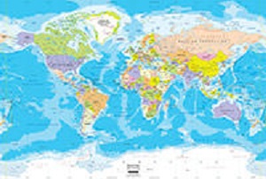
Our political world maps are very popular. These maps depict major cities, national capitals, rivers, lakes, glaciers, mountain peaks, and latitude/longitude lines. Each country is given its own color blocks, as well as each US state and Canadian province. Each version of a political map comes with its own extra features. One displays ocean bathymetry; another combines antique ocean colors, and rich earth tones to lend the map an antique appearance; another depicts major seas, bays, straits, and major and minor islands; another brings shaded relief to the world’s terrain.
For the classroom, we have contemporary political wall maps complete with flags of all the world’s nations shown at the bottom. These maps are among the most detailed single sheet wall maps available today. They include thousands of place-name labels, including labels for national and state capitals, international and state boundaries, bodies of water, mountain ranges, and much more. Countries are delineated with solid blocks of color, and boundaries are defined in red outline. Extensive labeling enhances the capabilities of this map as a valuable reference.
Less popular than our political wall maps are our physical wall maps, which focus primarily on natural elements in the world, such as elevation and current. One of our many world wall maps uses incredibly detailed imagery of the Earth’s topography and bathymetry as derived from numerous global and regional data sets to create a map of stunning azure beauty. Though the map is printed on flat media with no raised relief, a visual relief is created by the use of shading to portray the Earth with the illusion of three-dimensionality. The map represents a global relief model of the Earth's surface and is a great reference for exploring the planet's terrain and ocean floor. All countries, U.S. states, and Canadian provinces are labeled on the map with political boundaries outlined in red.
World Maps Online is an online retailer and fabricator that specializes in high-quality printed maps and large-format map murals for schools, homes, and businesses. Our cartographic and design service gives our customers the opportunity to fully customize many of our products. Our long list of satisfied customers includes school districts, interior designers, non-profit organizations, businesses, government agencies, and individual map lovers of all ages.
